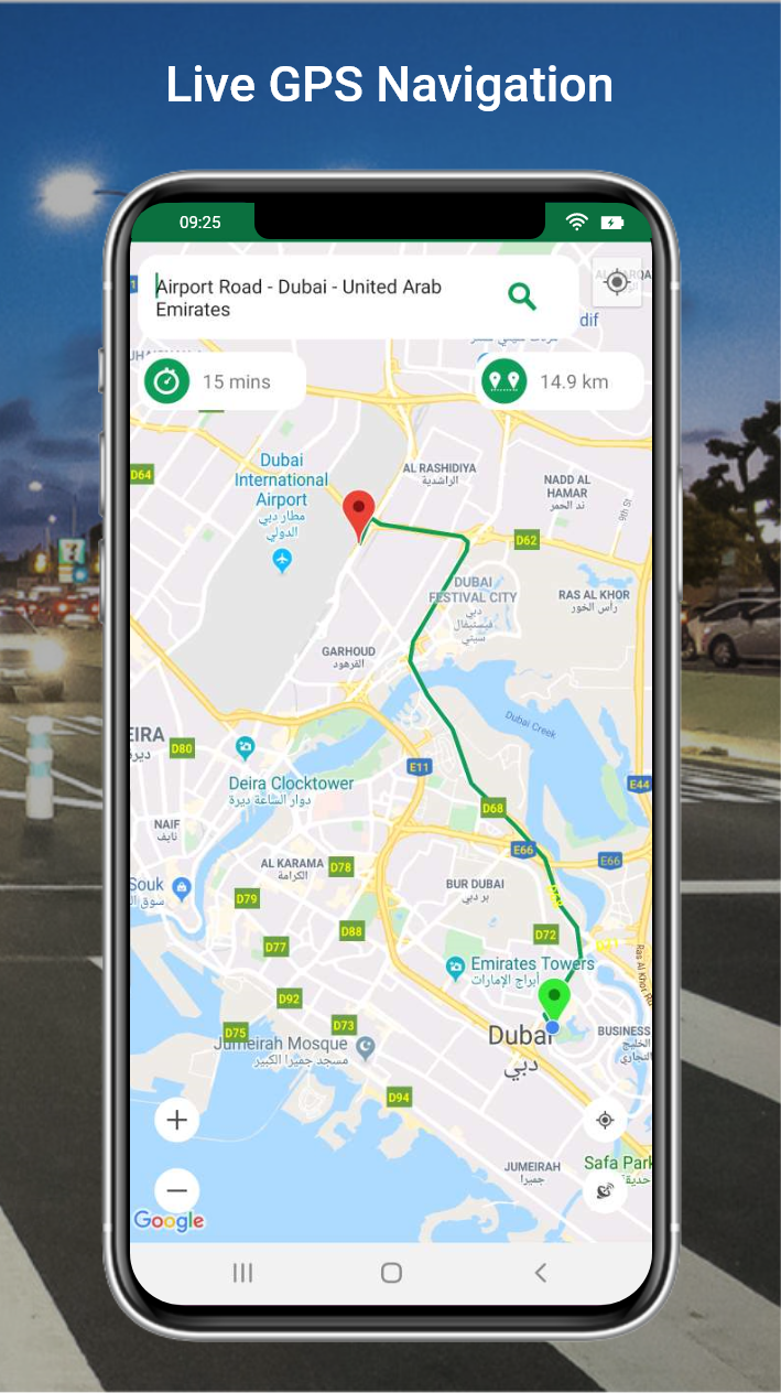
ใหม่! grab navigation ระบบนำทางในแอป
สะดวก ครบ จบ ในแอป grab driver
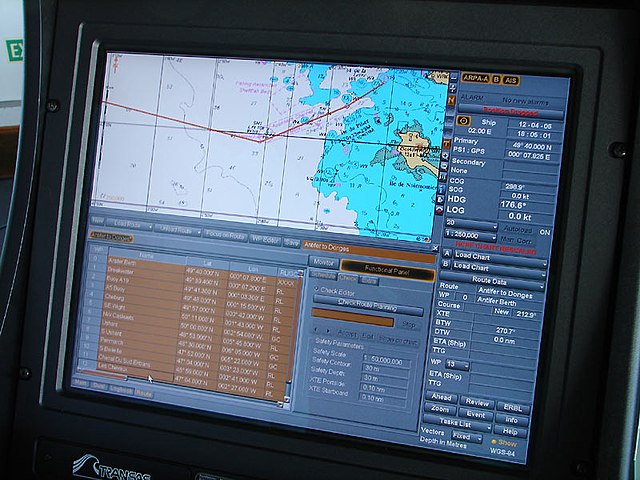
เพื่อเส้นทางที่ดีที่สุด ในทุกการเดินทาง พาร์ทเนอร์ย่อมใช้ระบบนำทาง ที่เชื่อมต่อได้จากแอปคนขับโดยตรง จากนี้ เพิ่มความสะดวกยิ่งขึ้น แกร็บได้เชื่อมต่อ google maps เข้าสู่แอป grab driver เพื่อการดูเส้นทางในแอปคนขับได้โดยตรง ควบคู่ไปกับการรับงานในแอป โดยไม่ต้องสลับแอปอีกต่อไป
ถาม: ฉันสามารถตั้งค่าให้ระบบนำทางที่ฉันเลือกเป็น ค่าเริ่มต้น ได้อย่างไร?
ตอบ: หากพาร์ทเนอร์ต้องการตั้งค่าให้ทุกการเดินทาง เริ่มต้นด้วยระบบนำทางที่ต้องการ ทำได้ตามขั้นตอนดังนี้
1. กดแถบ 'บัญชี' ในแอป grab driver
2.
 เลือก 'ผู้ให้บริการนำทาง'
3. เลือกระบบนำทางที่ต้องการให้แสดงเป็นค่าเริ่มต้น
ถาม: ฉันสามารถใช้ระบบนำทางในแอป grab navigation ในขณะที่ไม่ได้รับงานได้
หรือ
ไม่?
ตอบ: ไม่สามารถใช้ได้ พาร์ทเนอร์จะสามารถใช้ grab navigation ในขณะที่รับงานเท่านั้น
ถาม: หากฉันรับงานต่อเนื่อง เส้นทางของ grab navigation จะอัปเดตทันทีหรือไม่?
ตอบ: เมื่อพาร์ทเนอร์กดรับงานหรือระบบรับงานให้อัตโนมัติ grab navigation จะอัปเดตเส้นทางทันที
ถาม: หากลูกค้าต้องการเพิ่มหรือเปลี่ยนแปลงจุดหมายปลายทาง เส้นทางของ grab navigation จะอัปเดตทันทีหรือไม่?
ตอบ: ใช่ grab navigation จะอัปเดตเส้นทางทันที เมื่อลูกค้าได้แก้ไขหรือเพิ่มจุดหมายปลายทางในแอป
ถาม: เส้นทางใน grab navigation คำนวณจากอะไร?
ตอบ: grab navigation จะแสดงเส้นทางที่เดินทางได้เร็วที่สุดในช่วงเวลานั้นๆ โดยอัตโนมัติ
ถาม: ฉันสามารถตั้งค่าหลีกเลี่ยงค่าผ่านทางใน grab navigation ได้หรือไม่?
ตอบ: ในช่วงทดลองให้บริการขณะนี้ grab navigation ยังไม่รองรับการตั้งค่าหลีกเลี่ยงค่าผ่านทาง ทั้งนี้พาร์ทเนอร์สามารถสอบถามลูกค้าได้ว่าต้องการใช้ทางด่วนหรือไม่ เพื่อเลือกใช้เส้นทางที่เหมาะสม.
เลือก 'ผู้ให้บริการนำทาง'
3. เลือกระบบนำทางที่ต้องการให้แสดงเป็นค่าเริ่มต้น
ถาม: ฉันสามารถใช้ระบบนำทางในแอป grab navigation ในขณะที่ไม่ได้รับงานได้
หรือ
ไม่?
ตอบ: ไม่สามารถใช้ได้ พาร์ทเนอร์จะสามารถใช้ grab navigation ในขณะที่รับงานเท่านั้น
ถาม: หากฉันรับงานต่อเนื่อง เส้นทางของ grab navigation จะอัปเดตทันทีหรือไม่?
ตอบ: เมื่อพาร์ทเนอร์กดรับงานหรือระบบรับงานให้อัตโนมัติ grab navigation จะอัปเดตเส้นทางทันที
ถาม: หากลูกค้าต้องการเพิ่มหรือเปลี่ยนแปลงจุดหมายปลายทาง เส้นทางของ grab navigation จะอัปเดตทันทีหรือไม่?
ตอบ: ใช่ grab navigation จะอัปเดตเส้นทางทันที เมื่อลูกค้าได้แก้ไขหรือเพิ่มจุดหมายปลายทางในแอป
ถาม: เส้นทางใน grab navigation คำนวณจากอะไร?
ตอบ: grab navigation จะแสดงเส้นทางที่เดินทางได้เร็วที่สุดในช่วงเวลานั้นๆ โดยอัตโนมัติ
ถาม: ฉันสามารถตั้งค่าหลีกเลี่ยงค่าผ่านทางใน grab navigation ได้หรือไม่?
ตอบ: ในช่วงทดลองให้บริการขณะนี้ grab navigation ยังไม่รองรับการตั้งค่าหลีกเลี่ยงค่าผ่านทาง ทั้งนี้พาร์ทเนอร์สามารถสอบถามลูกค้าได้ว่าต้องการใช้ทางด่วนหรือไม่ เพื่อเลือกใช้เส้นทางที่เหมาะสม.
Learn more with Plus
Android auto and apple carplay are driving apps that essentially mirror your smartphone to a compatible display unit in your car.
 The gps runs through your phone, so it's a really handy way to add navigation features to a car that doesn't have built-in gps. However, these apps fall into a bit of a legal grey area. While you don't need to access the phone once it's connected to the display unit, it's technically still in use in the vehicle. Australian states and territories don't specifically mention android auto or apple carplay, aside from victoria which specifically prohibits their use for learner, p1 and p2 drivers.
As you learned in links , the <a element with the href attribute creates links that users can follow by clicking or tapping. In lists , you learned how to create lists of content. In this section, you will discover how to group lists of links together to create navigation. There are several types of navigation and several ways to display them. Named anchors within text linking to other pages within the same website are considered local navigation. Local navigation that consists of a series of links displaying the hierarchy of the current page in relation to the site's structure, or the pages the user followed to get to the current page, is called a breadcrumb.
I have had the immense pleasure and honor working with these amazingly professional and so kind and the patience of job, i might add. This patent team of men and women, my direct person angel for the crazy questions i would ask at breakneck speed and sometimes through tears… he always maintained such a peaceful, calm demeanor all the while seeing and hearing my vision. As well as miguel and gilbran along with angelia they could not have been more sweet and knowledgeable and very well versed in making sense of things for me. Christian, who i know i would call ( once on a sunday morn, which i did only because i felt it was urgent) he took my call and put all my fears at bay without hesitation and was never abrupt or rushing.
Mapbox ev routing is available in private preview via directions api. To learn more, read the api documentation. For pricing and accessing ev routing, reach out to mapbox sales.
11. TomTom GO Navigation
Be it planning your drives, exploring new places, staying ahead of the traffic, or being up to date with the happenings on the road — tomtom solutions take you along the way. Go navigation traffic, safety cameras, and offline maps all in one easy-to-use smartphone app get safety cam alerts stay ahead of every safety camera along your route explore tomtom roadtrips.
• first of all, by passing over all roads with gps, all the information about the roads and the shapes and curves of the roads etc. Are obtained. All of its features are collected from the field. In the collected data, speed information of the road, turn bans, etc. There is also information such as • this collected data is used by navigation software such as igo, garmin, tomtom etc. Loaded into a navigation software. • the user, who sets out with this map and the navigation device with the software installed, sets a destination using the interface of the software.
18. Sygic GPS Navigation & Maps
Having used gps navigation, it's hard to go back to using maps. Rail and inland navigation together account for 30–50% of the total delivered cost. The stars were used for navigation in the desert. A gps navigation device a global satellite navigation system for the air force navigation beacons for allied aircraft small boats equipped with electronic aids to.
We don’t recommend navigation systems under $50. The quality of information in these models will be lacking, and feature sets will be small. Maps may be poor with few, if any, updates. A top-of-the-range model costs more – around $350 at the upper end – but for that price you get the most important features, including lifetime upgrades. These models are well worth the investment, particularly if you travel frequently to unfamiliar places. Did you know? nickel cadmium batteries suffer from “memory effect. ” their ability to hold a charge decreases over time. Higher-quality gps units use lithium ion batteries. Staff bestreviews.
Navigation toolbox provides algorithms and analysis tools for motion planning, simultaneous localization and mapping (slam), and inertial navigation. The toolbox includes customizable search and sampling-based path planners, as well as metrics for validating and comparing paths. You can create 2d and 3d map representations, generate maps using slam algorithms, and interactively visualize and debug map generation with the slam map builder app. The toolbox provides sensor models and algorithms for localization. You can simulate and visualize imu, gps, and wheel encoder sensor data, and tune fusion filters for multi-sensor pose estimation. Reference examples are provided for automated driving, robotics, and consumer electronics applications.
Sygic truck & caravan gps navigation sygic travel.
Components built for iOS and Android
Mobile apps are rarely made up of a single screen. Managing the presentation of, and transition between, multiple screens is typically handled by what is known as a navigator. This guide covers the various navigation components available in react native. If you are getting started with navigation, you will probably want to use react navigation. React navigation provides a straightforward navigation solution, with the ability to present common stack navigation and tabbed navigation patterns on both android and ios. If you're integrating react native into an app that already manages navigation natively, or looking for an alternative to react navigation, the following library provides native navigation on both platforms: react-native-navigation.
Comments
Post a Comment